Tehran’s modernization continued into the Second Pahlavi period. The redesigned city, with its new pattern of streets, prepared the urban setting for the first comprehensive master plan of the capitol. In 1966, the Iranian government asked the American firm Gruen Associates to draw up a comprehensive plan for the city, together with celebrated Iranian architect Abdolaziz Farmanfarmaian.
“The Tehran Comprehensive map,” as it was called, was approved in 1970 by the City Council for Town Planning and Architecture. This map defined two boundaries for Tehran: an already existing border, as well as a forecasted boundary, twenty-five years hence. The appropriately-named Supervisory Council for the Expansion of Tehran, and the High Council for Town Planning and Architecture enforced development policies.
Gruen’s plan formed a framework for satellite towns, apartment complexes, office buildings, parks, palaces, highways, road systems and other facilities built in and around Tehran between the mid-1960s and the Islamic Revolution of 1979. According to Robin Wright, “Urban transformation in Tehran not only helped in establishing the national and international importance of the capital, but also had immediate economic and social impacts by providing a new source of revenue for the government.” In spite of the new structure of the city, with its wide streets and modern buildings, the new master plan only focused on physical development. It did not deal with social, cultural, and economic issues. Modern urban life had effectively been ignored.
The process of modernization in Iran was accompanied by a wave of destruction and changes, which changed the face of the country’s cities and modified the structure of existing urban areas. “Main streets cut through the center of districts and old roads and squares confronted a new configuration,” according to Ali Madanipour. “Structures of districts, streets and squares had a specific hierarchy before modernism.“ This new organization fragmented the city into many city centers, loosely connected to each other.
In the traditional city, religious institutions were the focal point of communal activity. Public spaces were dedicated to religious activities, and daily life under the authority of religious power. It included mosques, bazaars, and squares as the dominant buildings controlled by religious institutions. Now, the main street is the backbone of the urban social fabric, under the control of an autocracy. The difference could not be any greater.

The modernization of Iran has been rightly called “Westernization.” Undermining the country’s religious leaders led to the secularization of urban spaces in which religious institutions were not among the favored public institutions. “As the development of Tehran since the second half of the Nineteenth Century shows,” writes Sanjoy Mazumdar, “the number of mosques and other religious buildings declined. Nevertheless, after the Islamic revolution of 1979, religious leaders regained their powerful social role, combined with a political one; this new combination, together with the abolition of the monarchy and the disappearance of the communal social structure will have a new and potentially more complex, spatial manifestation.”
Although the Pahlavi dynasty tried to modernize different aspects of Iranian life, most importantly, it imposed a lifestyle that ignored Iranian desires to choose their own culture. In particular, the Pahlavis denied the pluralistic essence of Tehran’s culture, and attempted to homogenize it by force, within a relatively short period of time. This resulted in a clash of traditional social mores with Western-style modernism, and European-inspired nationalism. The consequence was public dissatisfaction, underground activities and new political organizations. Social life migrated to the privacy of the home.
Nevertheless, Iranians still found uses for their new, lifeless public spaces. Appropriately, they were turned into virtual tribunals for the people to directly engage the government. This latter activity made sense. The social and psychological dimensions of public space are part of the physical structure of any city. This is one of the reasons that streets and squares are so politically significant. The more that governments can physically define public space, and what it means, the more they can determine the way a society perceives itself.
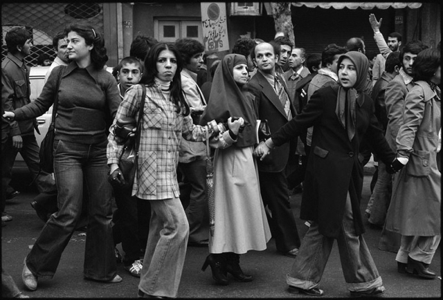
Given what transpired in the country following the Pahlavi Westernization program, one would be hard pressed to argue that the Iranian government succeeded. Events bear this out. In 1979, social tensions reached a boiling point. The Iranian people emerged from the underground to, Tehran’s streets and squares to challenge state power, and assert their rights to the city. Though not in reference to Islamic revolution, political scientist Marshall Berman described what happened in Tehran at the time best:
“This celebration of urban vitality, diversity, and fullness of life is in fact one of the oldest themes in modern culture. Throughout history into the Twentieth Century, this urban romance crystallized around the street, which emerges as a primary symbol of modern life. From the small-town “Main Street” to the metropolitan “Great White Way” and “Dream Street”, the street was experienced as the medium in which the totality of modern material and spiritual forces could meet, clash, interfuse, and work out their ultimate meaning and fates.”
Photographs courtesy of Wikipedia. Published under a Creative Commons license.
