Tehran is synonymous with turmoil. Since the 19th century, the city has been subject to everything from bouts of nationalism, to monarchism and religious revivals. This history intersects with a growing population, of distinct cultural and geographic origins, that emigrated from other parts of the country, after forced modernization during the 1930s. Unsurprisingly, the metropolis has since witnessed two revolutions, a number of assassinations, and several protest movements.
The 1979 Revolution and Green Revolution, in June 2009, have left the biggest of marks on Tehran, imbuing its civic culture with a hope for progress and civil rights, and a understandable fear of political chaos and social and religious conflict. After the Westernization of Tehran in 1932 by Reza Shah, the city’s transformation resulted in a longterm struggle between Iran’s highly traditional society, and those seeking to modernize it.
The influence of the West has been the most critical factor in the restructuring of the Iranian capitol. Consequently, public spaces such as streets, squares, plazas, have been made more significant, albeit politicized, in ways that city planning did not anticipate. Logically, Tehran has become a place for resisting the government, as much as it has been remodeled in accordance with state interests.
Tehran’s transformation took place during three periods: First Pahlavi (the reign of Reza Shah, Second Pahlavi (the reign of Mohammad Reza Shah,) and the Islamic Republic of Iran. Paris was Reza Shah’s model. What had been a traditional Middle Eastern city, during the 1860s and 1870s, was remade under the influence of this archetypal European metropolis.
Originally featuring an enclosed urban structure, built to promote security and privacy, new buildings and wide, tree-lined streets appeared throughout Tehran, preparing the context for the more extensive and effective Westernization of the first Pahlavi period. Many of its features recall those of Paris, in different eras. Subsequently, Tehran acquired the shape of a modern city, with its wide and perpendicular boulevards and streets. However, its cultural modernization did not immediately follow.
“It was part of Reza Shah’s strategy to establish his authority after his ascension to the throne, which followed the revolution from 1906 to 1911. His capital was to become a unified space with a modern framework for development, an open matrix where goods and services could flow easily,” according to Ali Madanipour. The new urban structure imposed on Tehran was a network of wide streets and boulevards based on axiality, which replaced the twisted and organic alleys and streets, changing the morphology of the city’s entire urban area.
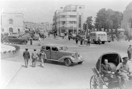
![Toopkhooneh Ghadeem, 1930s [Undated]](http://souciant.com/wp-content/uploads/2013/03/Toopkhooneh_ghadeem.jpg)
In the new Tehran, the main North-South road, Pahlavi Avenue and the East- West road, Shah Reza Avenue, ended in Niavaran and Shemiranat, the Pahlavi’s Palaces, governmental buildings, and the monuments of the Shah and his family. In addition, the main and important modern streets, public spaces, squares, parks were named after the royal family and their ideology, representing the glory and power of the Pahlavi dynasty.
The Parisian makeover was part of a larger program of Westernization, inspired by Mustafa Kemal Ataturk’s Turkey. Dubbed the “White Revolution,” the name given to these 1960s reforms betrayed, however crudely, its geographic inspiration. Curiously, the Pahlavi dynasty was also trying to instill nationalism in Iranians, by simultaneously reviving the glory of the pre-Islamic Achaemenid Empire. For instance, in important state buildings, such as the Ministry of Foreign Affairs, the tall columns and ornamentation – including patterns, symbols – resembled Achaemenid palaces, not French government facilities.
Tehran’s modernization was followed by the first modern urban planning law in Iran. According to a 1982 Ministry of Housing and Development publication, “New legislation was introduced to foster this process. Legislation concerning building and widening of streets and alleys was passed in 1933 by the parliament.” In 1941, the Street Widening Act was revised and subjected to amendments in the 1966 Municipality Act. It was abolished in 1968 when the Urban Development and Redevelopment Act was introduced.
The imposition of new roads and networks of transportation on the old fabric of the city increased the number of cars and vehicles, while leaving the public squares and plazas less integrated within the network of the city. A network of new streets was laid out to cut across many urban areas around the country in order to break down the existing social structure, a communal heterogeneity housed in a quarter system.
Accordingly, these new strategies attempted to overcome persisting feudal factionalism, by linking separate residential neighborhoods and imposing a framework on them, unifying city space in order to encourage the homogenization of Iranian society. [A pluralistic society, on the other hand, contradicts and undermines the control of autocratic governments.] The scale of the project is only made possible by the increase of centralized political power and the expansion of the bureaucracy within Reza Shah’s regime. Thus, as Ali Madanipour writes, “In spatial terms, the growing power of the state is reflected in the new spatial structure of Tehran.”
Photographs courtesy of Wikipedia. Published under a Creative Commons license.